TALKING POINTS
Please sign up for Save East Rocklin’s Newsletter for more detailed information. Go to Save East Rocklin’s website main page and select “JOIN OUR NEWSLETTER”.
College Park Talking Points
108-acres of high density residential development will impact:
- Traffic on Rocklin Road and other local surface streets including cut through traffic on El Don Drive.
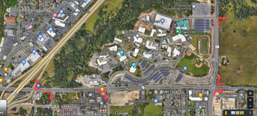
Much development has already been approved and developed in east Rocklin along and nearby the major arteries of Rocklin Road and Sierra College Blvd. Everyone in the east Rocklin community is aware of the intense traffic congestion from Sierra College campus student traffic on Rocklin Road between I-80 and Sierra College Blvd. None of these prior projects EIR’s were approved with improvements to these heavily traveled roads. Rather their traffic impacts were ignored with continual future promises of improvements namely the widening of Sierra College Blvd. and Rocklin Road from 4 to 6 lanes. None of those improvements have ever been made and are now no longer planned. Now the most massive development to hit this pocket area of Rocklin also has no plans for road improvements. The city will allege they are doing a study for yet again future improvements. The new future plan is to make improvements to the I-80/Rocklin Road interchange however many City of Rocklin officials have stated the City does not and will not have the money for such a traffic circulation project. Of more importance… even if the so called
I-80/Rocklin Road Interchange Project were to be implemented as currently proposed with no actual widening of the I-80/Rocklin Road underpass this would not solve the congestion problems on Rocklin Road when school is in session. The I-80/Rocklin Road Interchange Project is yet another City ruse to satisfy CEQA requirements and an attempt to placate Rocklin residents. The City, as before, has no intentions of actually making traffic circulation improvements to Rocklin Road or Sierra College Blvd.
Save East Rocklin demands the following traffic mitigation measures be implemented PRIOR to any development:
- The City and/or the College Park developer shall make and pay for the following improvements to Rocklin Road (and Sierra College Blvd) PRIOR to any development (the first 3 are a must):
Right hand turn lanes shall be installed at
- EB Rocklin Road at Aguilar Road
- EB Rocklin Road at El Don Drive
- WB Rocklin Road at the I-80 on ramp
- WB Rocklin Road at Sierra College Blvd.
- NB Sierra College Blvd at Rocklin Road
- NB Sierra College Blvd at entrance to College Park North 72-acre site (developer may already be proposing)
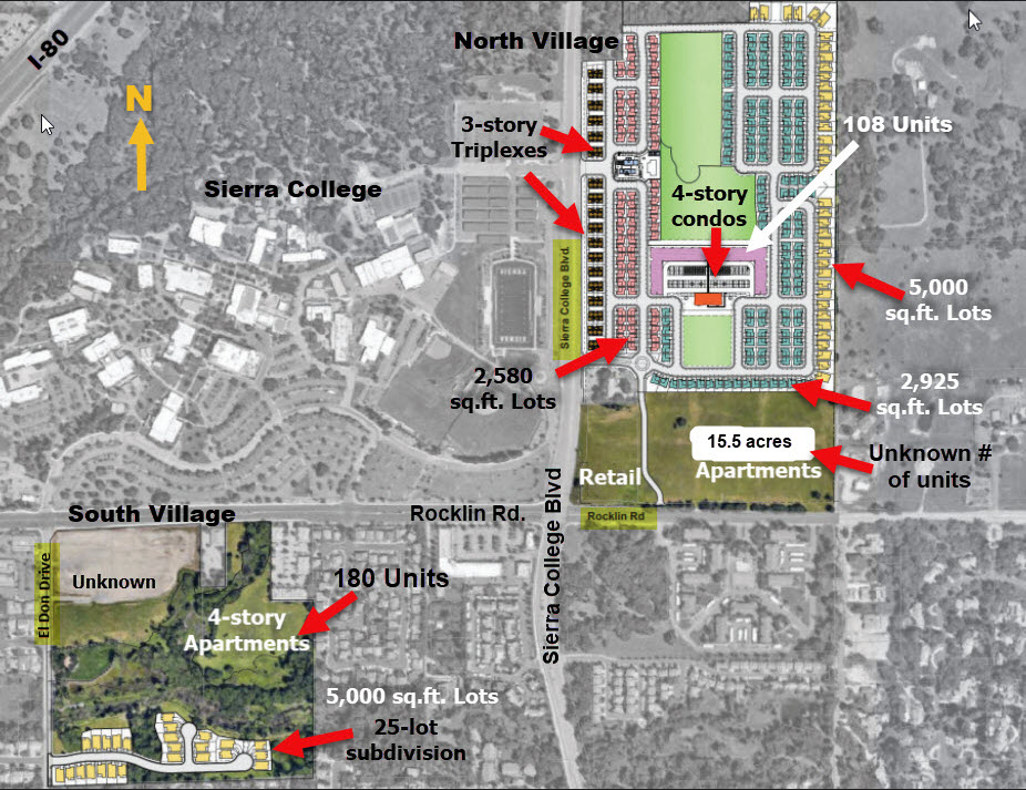
- Proposed High-Density Residential “Mixed Use” Zoning is too high allowing for hundreds of tiny lot homes, 4-story condos and apartments, and 3-story triplexes.
The City of Rocklin General Plan Land Use Designation for the entire108-acres of the College Park development is “Mixed Use”. The General Plan Land Use Element category of “Mixed Use” equates to 10 to 40 dwelling units per acre.
Reference: Chapter IV A – Land Use Element of the City of Rocklin General Plan
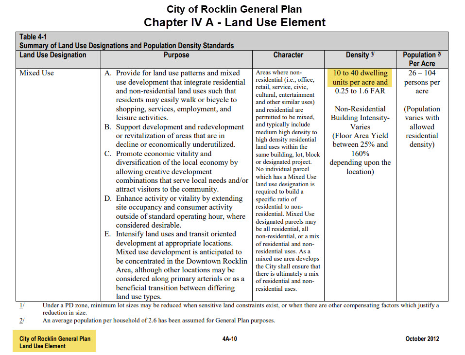
Save East Rocklin believes the development as currently proposed is too dense at 40 units to the acre. College Park as currently proposed is the densest project in all of Placer County.
Save East Rocklin is asking the City Council to only approve the lower end of zoning of 10 units to the acre to reduce the number of housing units down from almost 1,000 thus reducing impacts on the east Rocklin community.
College Park at its current density allows for a row of 3-story triplexes all along Sierra College Blvd. on the west side of the project, a four-story condominium complex and potentially multiple 4-story apartment units along with single family residential homes on lots as small as 2,500 sq. ft.

Additionally and according to local realtors another major concern is that this type of high-density, small lot residential development will attract corporate investors who will buy these up and turn them into high priced rental properties. This goes against the primary reason for high-density development which is to provide “affordable” housing to local residents.
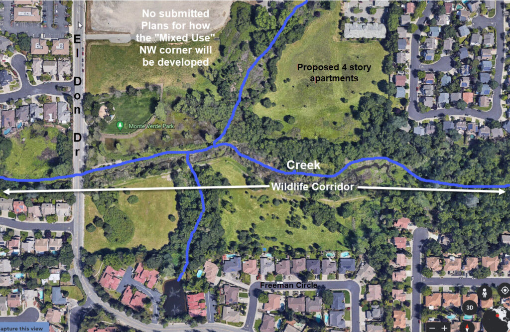
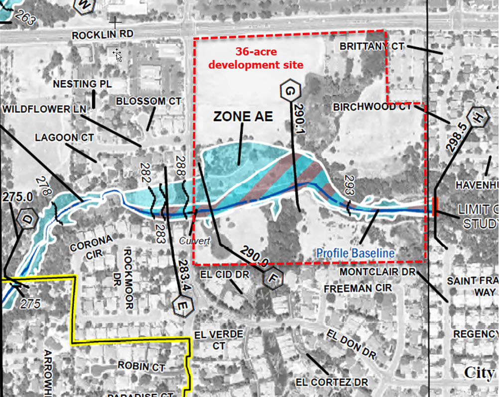
- Protect the creek and preserve the wildlife corridor on the College Park 36-acre South site by increasing the development setbacks from the creek’s bank from 50’ to a minimum of 100’.
Hundreds of wildlife species including fox, deer, coyote, bobcat, raccoons, beaver, river otters, minks, wild turkeys, Western Pond Turtles, multiple species of raptors including White-tailed Kite, Great Egrets, Blue Herons, Great Horned owls, many species of ducks including Merganser ducks and many more reside in and traverse the areas around the feeder creek to Secret Ravine creek.
Refer to Save East Rocklin’s Wildlife photo gallery.
Additionally, many residents in east Rocklin currently use the SPMUD easement road that runs parallel to the creek for nature walks. This would be destroyed with only a 50’ foot setback from the creek. Save East Rocklin does NOT want this trail to be paved by the developer.
- Development should not be allowed near FEMA flood zone on the College Park South site. Such development is in direct conflict with Rocklin Municipal Code Chapter 15.16 – FLOOD HAZARD AREAS which states:
A. Restrict or prohibit uses which are dangerous to health, safety, and property due to water or erosion hazards, or which result in damaging increases in erosion or flood heights or velocities;
B. Require that uses vulnerable to floods, including facilities which serve such uses, be protected against flood damage at the time of initial construction;
C. Control the alteration of natural floodplains, stream channels, and natural protective barriers, which help accommodate or channel floodwaters;
D. Control filling, grading, dredging, and other development which may increase flood damage; and
E. Prevent or regulate the construction of flood barriers which will unnaturally divert floodwaters or which may increase flood hazards in other areas.
FEMA FLOOD ZONE MAP
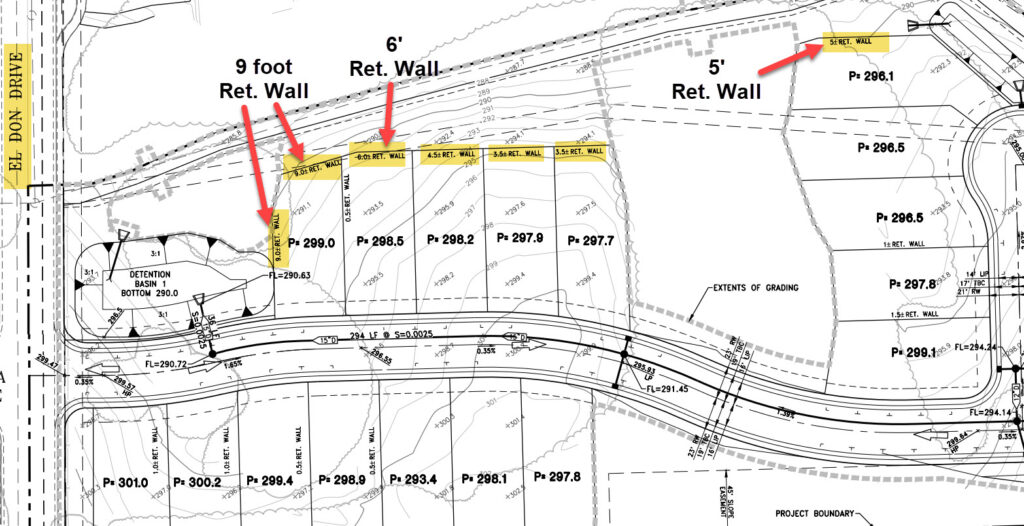
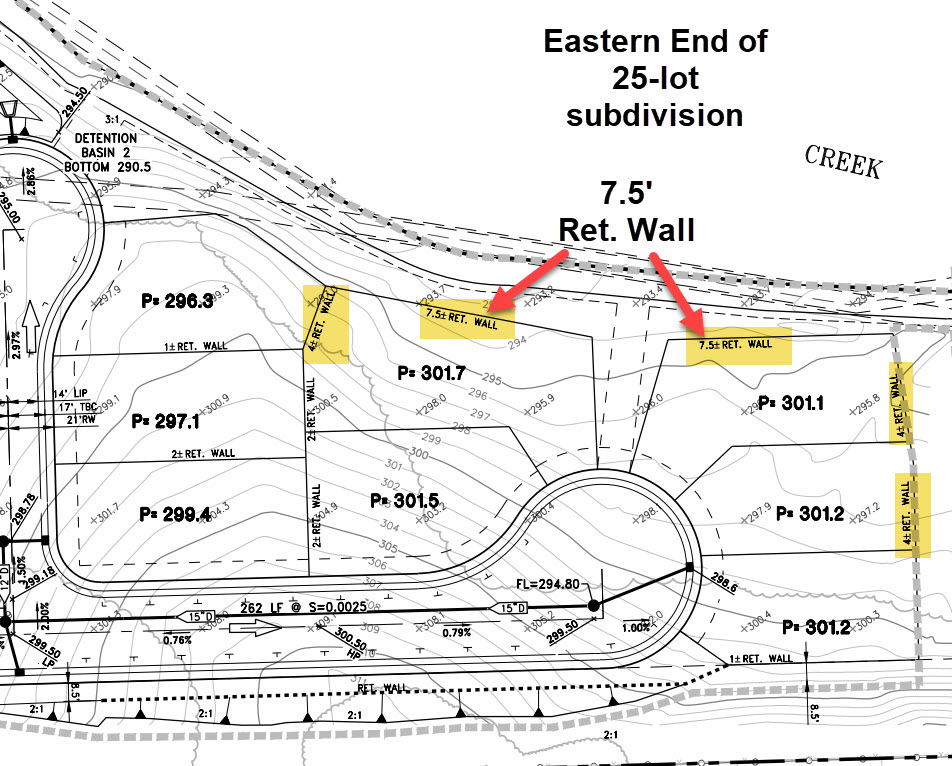
- Do not allow developer to install high retaining walls along southern portion of creek on the College Park South site – some are proposed at almost 10’ in height. Conveniently buried in the developer’s Preliminary Grading and Drainage documentation you will see that the developer is proposing extremely high retaining walls along the northern, western and eastern borders of the 25-lot subdivision proposed on the College Park South site (south of Monte Verde Park and the creek). Incidentally you must zoom in about 500 percent to actually see the notations regarding the retaining walls. We found the latter quite concerning as the general public would never think to look for this information given its hidden location. Below are enlarged sections of this map showing 9 foot tall retaining walls on north western side of subdivision and 7.5 foot tall retaining walls on the north eastern side of subdivision.
Save East Rocklin strongly objects to any retaining wall over 2 feet in height. Perhaps if the developer was not proposing to develop in a flood zone these high retaining walls would not be necessary.
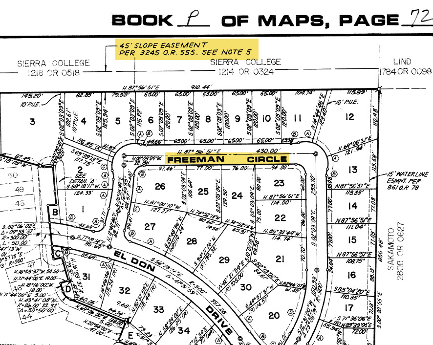
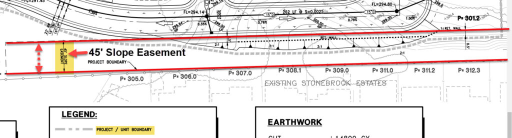
- Developer cannot develop within the Freeman Circle homes 45’ slope easement on the College Park South site. There exists a 45’ Slope Easement behind all the homes on Freeman Circle that border the College Park South project site. Save East Rocklin has presented several attorney letters to the City legally objecting to any form of development within this 45’ slope easement. Once this information was presented to the City, the developer reduced the number of proposed lots and moved all house lots outside the easement. However, the developer is still trying to intrude into the easement with an access road and retaining walls. Again you must refer to the hidden Preliminary Grading and Drainage map to see the developer’s plans to put an access road within the 45’ easement. Again be sure to zoom in about 500 percent to see.
Save East Rocklin objects to any form of development including an access road within the 45’ slope easement belonging to the owners of the Freeman Circle homes bordering the college property.
Placer County Recorders Map
Preliminary Grading and Drainage Map
- Grading – grading of ALL land must be kept at a minimum (not to exceed 2-4 feet in height) or we will end up with another Granite Bluffs with newly constructed homes towering over existing neighbor’s homes.
Deanna Ellis of Cresleigh Homes stated to Save East Rocklin and developer’s attorney George Phillips that they did not need to grade more than 2 feet on the College Park south site’s 25-lot subdivision.
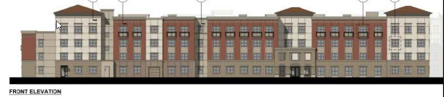
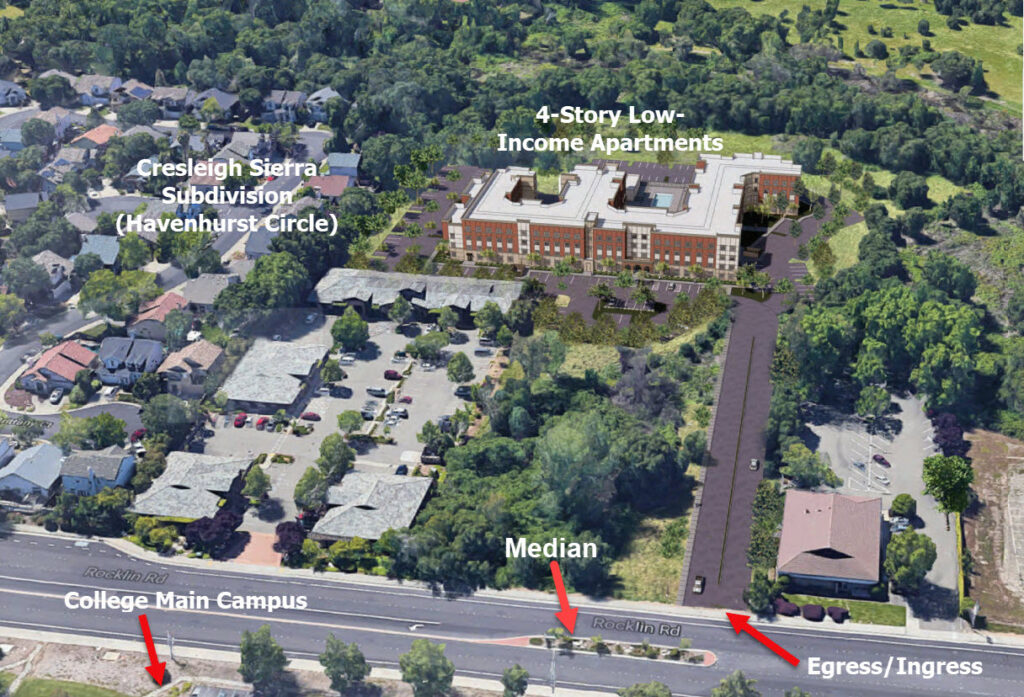
- 4-story, 180-unit low-income apartments (Sierra College Senior Apartments) proposed on 7.3 acres on the College Park South site (NE corner directly off Rocklin Road):
- These apartments should be moved from the small 7 acres on the College Park South site to the College Park 72-acre North site where there is twice the acreage of undesignated “Mixed Use” land available which would provide better traffic circulation and the potential for more affordable housing units.
(There are 15 acres along Rocklin Road on the North site directly across from the Rocklin Manor Apartments available for this project. Currently there are no submitted plans for this 15+ acres of land. The North site location is a much more suitable site for this project. )
- At the current proposed location on the College Park South site there is an existing median on Rocklin Road at the entrance/exit that inhibits traffic circulation (right hand turns only) and would affect emergency vehicle traffic. There are no traffic circulation problems on the North site.
- At the current location with only 7 acres available for this project the developer must go up 4-stories to get 180 units. 4-story apartments will tower over existing neighborhoods. This would not be the case if the project were moved to the North site farther down Rocklin Road.
- Require developer to move underground all existing overhead utilities that run along project perimeters.
- Loomis and Loomis Schools must be fairly compensated for the impacts of College Park’s North site regarding traffic and school impacts. Note: Sierra College Blvd. is the dividing line between Rocklin and Loomis school districts. The bulk of school impacts with new students and driving those students to Loomis schools on Loomis roads will be on Loomis.
Loomis and Loomis Schools must be fairly compensated for the impacts of College Park’s North site regarding traffic and school impacts. Note: Sierra College Blvd. is the dividing line between Rocklin and Loomis school districts. The bulk of school impacts with new students and driving those students to Loomis schools on Loomis roads will be on Loomis.